

Reports
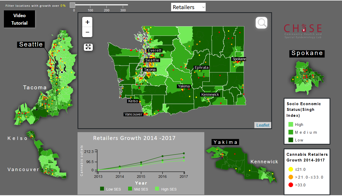
How does the growth of Washington state’s cannabis industry relate to neighborhood socioeconomic characteristics?

Recreational use of cannabis is legal in the District of Columbia and 10 states. Washington State was first to legalize the recreational use of cannabis in 2012. Despite the growing legal availability of recreational cannabis, little is known about the impact of cannabis outlet availability on our local communities.
Eastern Washington Health Profile
The Eastern Washington Health Report aims evaluated the community health status and health issues known to affect individuals and communities in eastern Washington. We compared this region of the state and its distinctly different set of health and social issues to those in western Washington.

Access to Broadband in Washington State - A Brief Report
The Access to Broadband Report aims to identify areas within the Washington State with poor access to Broadband assess the relationship between access to broadband and health outcomes

Spokane Healthy Environment
The Spokane Healthy Living Environment Indicators (SHeLI) project aims to provide users with the ability to examine and identify healthy environments across the county. This web mapping application calculates an array of healthy indicators, like access to health services and healthy food outlets, at the parcel level, and allows users to explore the data and compare various regions. Data will be updated annually and more variables related to healthy environments will be added over time.

The Association Between School SES and Neighborhood Environment – The Case of Spokane City
Spokane public elementary schools vary substantially in their socioeconomic profile. This project uses geographic information systems combined with data on food outlets, greenspace, street networks, and crime to characterize the neighborhood environments around 34 elementary schools in the Spokane Public School system. We ranked schools into three groups based on the percentage of children receiving free-and-reduced meals, and tested whether these groups differed in environmental indicators like crime rate, proximity to major roads (used as a proxy for exposure to air and noise pollution), access to healthy food, and walkability within the surrounding neighborhoods. We found that crime rate, neighborhood walkability and proximity to major roads were all positively and significantly associated with the percentage of children receiving free-and-reduced meals.

Spatial Access to Health Services in Spokane County
Poor spatial access to health care services has been shown to directly impact health outcomes. This study maps an array of health services across Spokane county with the aim of identifying areas with poor spatial access.
